Navigation Programs - Ground-Based Navigation
The mission of the Ground-Based Navaids Team is to ensure National Airspace System (NAS) Ground-Based Navigation solutions are implemented in the most efficient and effective manner to satisfy customer needs. In addition, the Team serves as the program integrator with regional and HQ organizations.
Objective
To procure ground based navigation systems and equipment in order to meet new requirements and support existing systems.
Lighting Systems
The mission of the Lighting Systems is to develop, acquire, deploy, maintain, sustain and improve lighting products and services for the national airspace system.
Low Power Distance Measuring Equipment (LPDME)
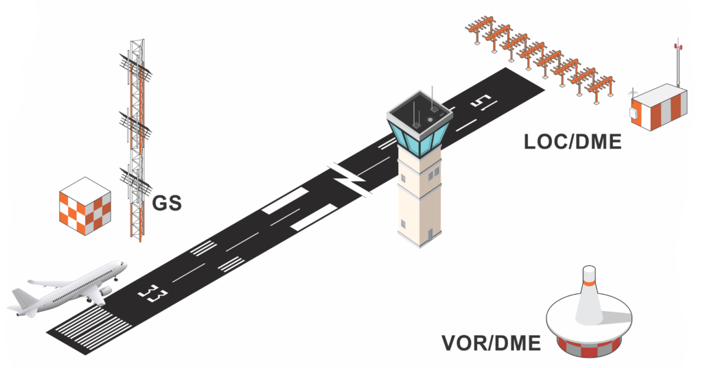
The Distance Measuring Equipment (DME) is a radio navigation aid used by pilots to determine the aircraft’s slant range from the DME ground station location. The DME avionics in aircraft send a pulse signal to the ground based DME, which responds with an answer pulse signal. The receiver in the aircraft measures the time delay between the sent and received pulses and calculates the slant range distance. There is no azimuth information, only distance.
Low Power DMEs (LPDMEs) transmit 100 watts of power and used for approach navigation. The LPDME is a component of Instrument Landing System (ILS) approach service for precision and non-precision approaches. The DME measures the distance from the aircraft to the runway out to 18 Nautical Miles (NM) and beyond. The LPDME can also be collocated with a VHF Omni-directional Range (VOR) to provide VOR/DME service with a Terminal Service Volume with a radius of 25 NM.
High Power DMEs (HPDME) transmit 1,000 watts of power and may be collocated with VORs to provide VOR/DME service with a Low and High Service Volume with a radius up 130 NM to support en route and terminal navigation. DMEs are used to support situational awareness and location of fixes for conventional flight operations and lateral guidance for DME/DME RNAV flight operations. Additionally, the distance information from a Tactical Air Navigation (TACAN) and a VOR/TACAN (VORTAC) unit is DME.
Presently the FAA has a contract with Selex Inc. to procure the Selex DME system. The Selex DME completed In-Service Decision in May 2015.
Very High Frequency Omni-Directional Range (VOR)
The Very High Frequency Omni-Directional Range (VOR) is a ground-based electronic system that provides azimuth information for high and low altitude routes and airport approaches.
Objectives
- Maintain a highly reliable, safe, and efficient ground-based navigation system through relocation or conversion to Doppler configuration of VOR facilities.
- Relocate VORs as needed.
- Upgrade conventional VORs as needed.
Ground-Based Navigation - Instrument Landing System (ILS)
The ILS has been the mainstay of landing navigation aids for well over 50 years. The modernized versions used by the FAA provide aircraft with precision vertical and horizontal navigation guidance information during approach and landing. Associated Marker Beacons and/or Low Power Distance Measuring Equipment (LPDME) identify distance to the runway. The attractiveness of ILS lies in the economy of its avionics costs and its wide international acceptance. Technology advances over the years have yielded great improvement in accuracy, dependability, and maintainability.
The GBNA (Ground Based Navigation Aids) supports all ground-based ILS systems in the National Airspace System (NAS) and will continue procuring and deploying new/replacement ILS for the foreseeable future. Presently the FAA has a contract with Thales ATM, Inc. to procure the ILS 420 system. The ILS 420 completed In-Service Decision in June 2015.
 The Localizer generates and radiates signals to provide final approach azimuth navigation information to landing aircraft. The antenna sends a VHF carrier signal with 90-Hz and 150-Hz sideband signals that the aircraft instruments determine as left and right of the centerline. The aircraft interprets the signal and displays them on the cockpit indicator guiding the pilot until the runway is in sight.
In a similar manner as the Localizer signal (just turned 90 degrees on axis), the Glide Slope sends a UHF carrier signal with the same two 90-Hz and 150-Hz sideband frequencies that aircraft instruments determine as above or below the desired glide path. This is approximately 3 degrees to the horizon which gives the aircraft a descent rate of approximately 500 feet per minute.
An ILS precision approach and landing requires several components. For properly ILS-equipped aircraft certified for the category of service utilized, the ground-based ILS systems are the electronic processing and antenna components. The runway requires proper lights and markings along with an approach lighting system. Other components may be required such as Runway Visual Range (RVR) and Marker Beacons or LPDME. Note that the more precise the approach is (lower weather minimums/visibility) the more ancillary components may be required.