Ground-Based Navigation Aids, known as NAVAIDs, are critical to the U.S. transportation infrastructure. The flying public and military depends on the safety and reliability of this infrastructure. The FAA’s NAVAIDs are some of the oldest in the world. Here is the different systems provide navigation to pilots.
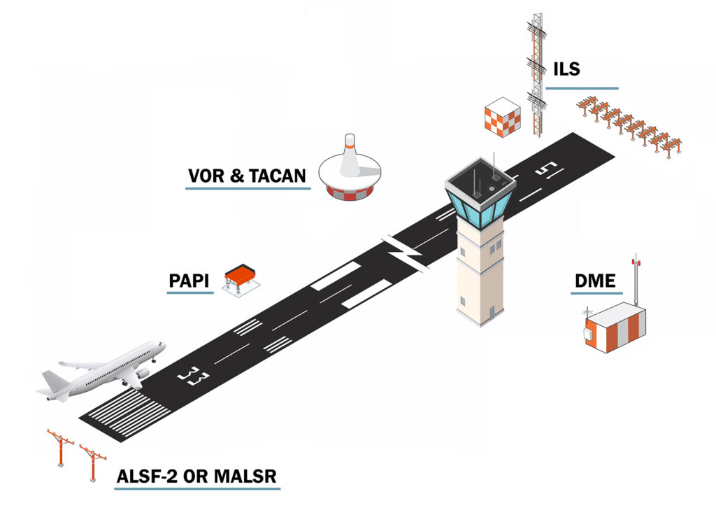
DME
Distance Measurement Equipment (DME) provides slant range information to all aircraft and enables RNAV service for air carrier aircraft. DMEs can either be used as part of an ILS, stand alone, or part of a VOR combination. TACANs provide DME service as part of the signal in space. When not part of an ILS systems, DMEs are specifically located to provide two DME signal to an aircraft so that the aircraft can triangulate its position.
VOR
The Very High Frequency Omni-Directional Range (VOR) is a ground-based electronic system that provides azimuth information for high and low altitude routes and airport approaches. VOR can also be configured as a Doppler system (DVOR or Doppler Very High Frequency Omni-Directional Range) which increase the accuracy of the signal received by the aircraft. VOR can be located by itself, with a DME (VOR/DME) or more commonly as a VORTAC.
TACAN
Tactical Air Navigation (TACAN) provide azimuth information to military aircraft and slant range (DME) information to military and civilian aircraft. The azimuth information of a TACAN is used by military, similar to VOR azimuth information is used by commercial aircraft. The DME portion of the TACAN signal is used by military and commercial aircraft and can be located to provide two DMEs signal so that an aircraft can triangulate its position.
LIGHTING SYSTEMS
Approach Lighting Systems (ALS) provide visual information to help with aircraft landing when transitioning from instrument flight. A typical ALSF-2 system (High Intensity Approach Lighting System with Sequenced Flashing Lights) includes lights that are arranged in a specific pattern to communicate navigation information to the pilot. All lighting on airport runways provide critical information to the pilot to ensure safe movement on the airfield. Some other systems include:
MALSR (Medium Intensity Approach Lighting System With Runway Alignment Indicator Lights) is a medium approach intensity lighting system (ALS) installed in airport runway approach zones along the extended centerline of the runway.
PAPI (Precision Approach Path Indicators) primarily assists by providing visual glide slope guidance in non-precision approaches environment. PAPI is replacing Visual Approach Slope Indicator Lights (VASI).
As part of a moderation effort, the FAA is researching replacing incandescent lamps with more efficient Light Emitting Diode (LED) lamps.
ILS
Instrument Landing System (ILS) provide short-range guidance for aircraft to land. An ILS helps an aircraft find the correct approach path to land safely at night or in inclement weather. ILS uses a local low power DME to provide distance information as well.
NAVAID SHELTERS
Buildings, towers, antennas, and equipment cabinets provide the structure for the equipment. All NAVAID equipment is located in specific locations to provide accurate navigation signal to aircrafts. The buildings and associated equipment are critical to keeping the electronics working correct in different weather environments.
HIGHLIGHT
The mission of the Ground-Based Navaids Team is to ensure National Airspace System (NAS) Ground-Based Navigation solutions are implemented in the most efficient and effective manner to satisfy customer needs.